
La Palma
The Canaries’ Pretty Island
 |
The Palmeros also call their home La Isla Verde (the green island) – the lush greenary is in large part thanks to the highest rainfall in the Canaries. As a bonus the place remains quiet, unspoilt – and still relatively untouristed.
By Veronica Maria Garbutt
As our plane sweeps down to land, the 700 sq. km of San Miguel de La Palma (the island’s full name) looks like an inverted triangle. The northern green and fertile part is dominated by the towering Roque de Los Muchachos peak, and pine and laurel forests, while the south is craggier and drier. The giant crater of Caldera de Taburiente dominates the centre of the island, making this a haven for hikers, nature lovers, stargazers and volcanologists too.
Santa Cruz, La Palma’s capital, is all of colourful Canarian buildings, tiny shops with character and cobblestone streets. Charming pavement cafés can be found along the waterfront and in almost every flower-filled square. The city’s population is around the 18,000 mark so the “metropolis” manages to retain the atmosphere of a small town, while offering all the advantages of a capital city and port. Indeed this fourth most populous Canary Island boast just over 80,000 inhabitants, so you are unlikely to fe?l overwhelmed by crowds at any time.
Agriculture is the mainstay of the economy. High rainfall levels ensure good crops of bananas, grapes, avocados and tobacco. With an annual production of 150,000 tonnes, bananas are the main export item. They were introduced during the late 19th century from Indo-China. In the village of El Paso silk is still made by hand. And another minor industry is tobacco, with cigars from La Palma considered second only to those from Cuba. A small handicrafts industry centres on woodwork, basketry and embroidery. It ?s linked to the latest earner of foreign exchange – tourism. Fishing and honey production complete the island’s economic profile.
Historically the Amazonian sized first settlers were called Benahoaritas and the island called Benahoare, (My Homeland). The denizens’ origin is unknown. After the arrival of the Spanish, La Palma was incorporated into Castille in 1493. During the next century migrants from Spain, Portugal, Italy and the Low Countries arrived. By the 16th Century honey and sugar became the main exports, local pine provided timber for the fast growing shipyards and Santa Cruz became the third most important port of the Span?sh empire. The fortunes of La Palma rose and fell in line with the market for cash crops. And during lean periods many Palmeros emigrated to South America to look for new ways to make a living.
Time now to explore the island. Our first stop, naturally, is in Santa Cruz, built in an amphitheatre shape on the slopes of La Caldereta volcanic crater. Located in the east, about halfway down La Isla Bonita, the capital overlooks Gaunches as Timbucar Bay. This attractive city of colonial and modern whitewashed buildings cascades down the hillside to the sea, in narrow, winding streets.
The business section of the city, founded in 1493, centres on the harbour and yacht basin edged by a corniche called Avenida Maritima. Dominating the harbour is the imposing Cabildo Insular, the island’s local government council building. Don’t miss a stroll along Avenida Maritima for it is home to some of the most stunning Casas de los Balcones, elegant old Canarian houses with flower decked balconies, some sporting carved family coats of arms. A few metres inland Calle O’Daly (also known as Calle Real) i? the hub of Santa Cruz life. It is a long pedestrianised street named after an Irish banana merchant, and is lined with historic houses and residences.
The city centre proper is The Plaza de España. The grand colonnades on one side of this triangular “square” is the town hall. Its Renaissance façade and columns support an upper floor decorated with a plaque of King Felipe II of Spain. Inside – open during office hours – are exquisite Canarian wood panelling along with murals by Mariano de Cossio. For a relaxing coffee break try Café La Placeta nearby before strolling a little way southwards to Salazar Palace.
Now head south to Avenida Maritima and stop at Tobacco Vargas. Here you can see workers rolling Palmero cigars by hand --- just like in Cuba. In fact the industry developed as a result of migration between Cuba and La Palma. Continue along the seaside corniche until you get to Avenida de las Nieves. Here, near Plaza Almeda, stands a replica of the Santa Maria, the ship in which Christopher Columbus set off to discover the New World in 1492. Today it houses a maritime museum with a fine collection of flags,?charts and navigational instruments.
Nearby is the Museum of Natural History and Ethnology which showcases the island’s flora and fauna. Next door is the Fine Arts Gallery with its fine collection of Spanish and Flemish paintings. On the waterfront lies Santa Catalina Castle, built in the 16th century as a defence against pirate attacks. On the opposite side of Barranco de las Nieves lies La Virgen castle. The gunfire from both castles prevented the British Royal Navy under Sir Francis Drake from taking the island in 1585. Further along the s?ore, past the port and shipyards, lies Playa Nueva (New Beach), a wide sandy beach with football goals and volleyball nets. This is the place to chill out in town.
Heading north on our discovery tour, the first port of call is San Andres, a pretty seaside village of typical local houses set in cobbled streets and squares planted abundantly with flowers and palms. In the surrounding areas bananas, sugar cane and vegetables are cultivated. A few kilometres south lies Charco Azul, a natural swimming hole of saltwater pools with sunbathing platforms between them. This is a good place to stop for lunch or while away the afternoon before heading on to visit Los Sauces, a m?dern town which is home to El Regente Museum, dedicated to the culture of golfio. Golfio is the local staple-roasted sweetcorn flour which is added to soups, stews, puddings and ice cream.
Just 3 km west of San Andres lies a misty evergreen rainforest of ferns, lime, myrtle and moss covered laurel trees. This is los Tilos, a UNESCO biosphere reserve which is also home to blackbirds, chaffinch and several types of pigeon. A 20 km trail passing through several tunnels leads to a stunning set of waterfalls which are used to produce hydro-electricity. A much easier 1.5 km round trip trail with 800 steps leads to Mirador Topo de las Barandas, where there is a stunning view of the gorge. It starts?just behind the visitor centre, where you can also view a film about the biosphere, inspect a small museum and enjoy a drink or snack.
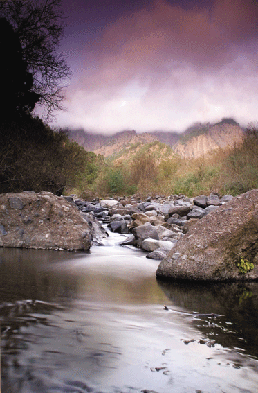
At the island’s heart lies The National Park of La Caldera de Taburiente. This vast depression rises to its highest point of 2420 m at the Roque de Los Muchachos. Owing to its unique flora, the Caldera is managed by ICONA, the national forestry agency. Before setting off to explore, be sure to pop into the helpful visitor centre where the staff will show you the best way to explore the crater. If you are not planning to hike or walk, there are some striking vistas to be had from various miradors (lookout p?ints). In the south there is La Cumbrecita, while at the northern end lies La Roque de Muchachos where you can look into the Caldera and discern the ocean through a sea of clouds below.
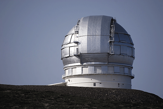
On the road to the peak lies the International Astronomical Observatory, which opened in 1985. It is one of the world’s most important observatories, housing Europe’s largest telescope and was built here for several reasons. The island’s clear air and clear sky at the peak is ideal for astronomy. Also La Palma’s remoteness means that the area is free of artificial light, and the shape of the mountain and the prevailing winds means that the airflow is not disturbed. All these add up to excellent conditions ?or stargazing!
Heading southeast towards La Palma be sure to stop at Mirador La Concepcion, from where there are more fine views. Just 3 km south of the city Los Cancajos with its dramatic rocky coastline is the summer playground of the capital’s denizens. It also attracts scuba divers a-plenty and if this is your interest check out Buceo Sub (email: buceosub@gmx.net) for introductory dives and water sports gear hire. Natour, the island’s main walking agency, is located here along with companies offering all manner of bo?t trips and island tours.
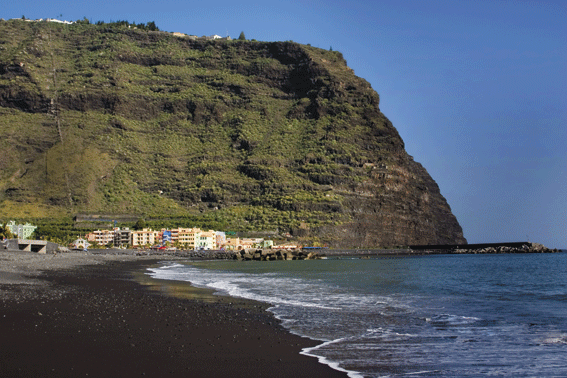
In the west lies La Palma’s second largest town, Los Llanos de Ariadne, set in a major banana-growing region. About 3 km east is El Paso, a small town noted for cigar making. Southwest is Puerto de Naos, location of the island’s best beach. It is a small but growing holiday destination clustered round a bay protected by tall rock cliffs. If you have more time to spare, consider visiting Tazacorte, Fuencaliente, Mazo and Barlovento. Finally, don’t miss the archaeological site of La Zarza, original home of t?e Benahoares – who left intriguing, rock carvings. A small museum on the site illustrates the everyday life of the ancient inhabitants and a video shows details of their diet, medical practices and burial rites.
Dining out on La Palma is a pleasure as the island’s cuisine is the basic Mediterranean diet, often enjoyed al fresco. Popular ingredients include fish, rice, sweetcorn, potatoes, tomatoes and watermelon. Goat and lamb are the main meats and typical fish include pez espada (swordfish) and dorada (sea bass). Most dishes are fried or roasted, usually served with mojo sauce made from olive oil, herbs and seasoning. Be sure to try Cabrito en Salsa (diced goat meat with a sauce of red peppers and herbs) or puch?ro, a stew of beans, chickpeas and vegetables. And to round off your meal there is bienmesabe, a syrupy cake made from eggs, sugar, almonds and honey.